Mapping & Surveying Drones
📸 What Are Mapping & Surveying Drones with Cameras?
Mapping and surveying drones are specially built to record georeferenced aerial imagery and data for land surveying, topography, 3D modeling, and GIS applications.
These drones are equipped with high-resolution cameras or sensors like LiDAR and RTK GPS to offer centimeter-level accuracy.
They are widely used by professionals in construction, agriculture, mining, environmental monitoring, and urban planning for faster data collection and better decision-making.
Showing all 4 results
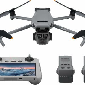
DJI Mavic 3 Pro – Triple-Camera Drone with 5.1K Video & Omnidirectional Obstacle Sensing
- Camera:
- Flight time (m):
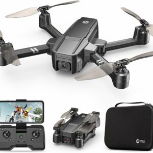
Holy Stone HS440 Foldable FPV Drone with 1080P WiFi Camera
- Camera:
- Flight time (m):
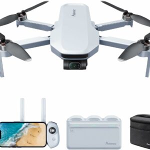
Potensic ATOM 3-Axis Gimbal 4K GPS Drone – Lightweight, High-Performance Aerial Photography
- Camera:
- Flight time (m):
🛠️ Key Features of Mapping & Surveying Camera Drones
- High-resolution RGB, multispectral, or thermal cameras
- RTK/PPK GPS modules for precise geolocation
- Long flight times and wide area coverage
- Automated flight planning and waypoint navigation
- Compatibility with photogrammetry and GIS software
- Capable of generating 2D orthomosaics and 3D models
🎯 Ideal Use Cases
Land Surveying & Topographic Mapping
Capture accurate aerial imagery to generate elevation models, contours, and boundary maps faster than traditional methods.
Construction & Infrastructure Monitoring
Track site progress, create as-built documentation, and identify issues in real time from the air.
Agriculture & Precision Farming
Use NDVI and multispectral data to monitor crop health, irrigation coverage, and detect disease or stress early.
Mining & Quarrying
Perform volume measurements, site planning, and safety monitoring with high-resolution aerial maps.
Environmental Research & Forestry
Monitor deforestation, land changes, and natural habitats with data that supports long-term analysis and sustainability efforts.
❓ Frequently Asked Questions (FAQs)
🔸 What is a mapping drone used for?
Mapping drones are used to capture aerial images and convert them into maps, models, and geospatial data used in construction, surveying, and agriculture.
🔸 How accurate are surveying drones?
With RTK or PPK modules, surveying drones can achieve centimeter-level accuracy—ideal for professional land development and GIS tasks.
🔸 Do mapping drones require special software?
Yes. The data collected is typically processed using photogrammetry software like Pix4D, DroneDeploy, or Agisoft Metashape to create orthomosaics and 3D models.
🔸 Can drones replace traditional land surveys?
While they may not fully replace legal surveys in every case, they drastically reduce time and cost for large-area data collection and topographic analysis.
🔸 What drone is best for surveying?
Multirotor and fixed-wing drones with RTK/PPK systems and high-quality cameras are commonly used. The best choice depends on your required accuracy, area size, and flight duration.